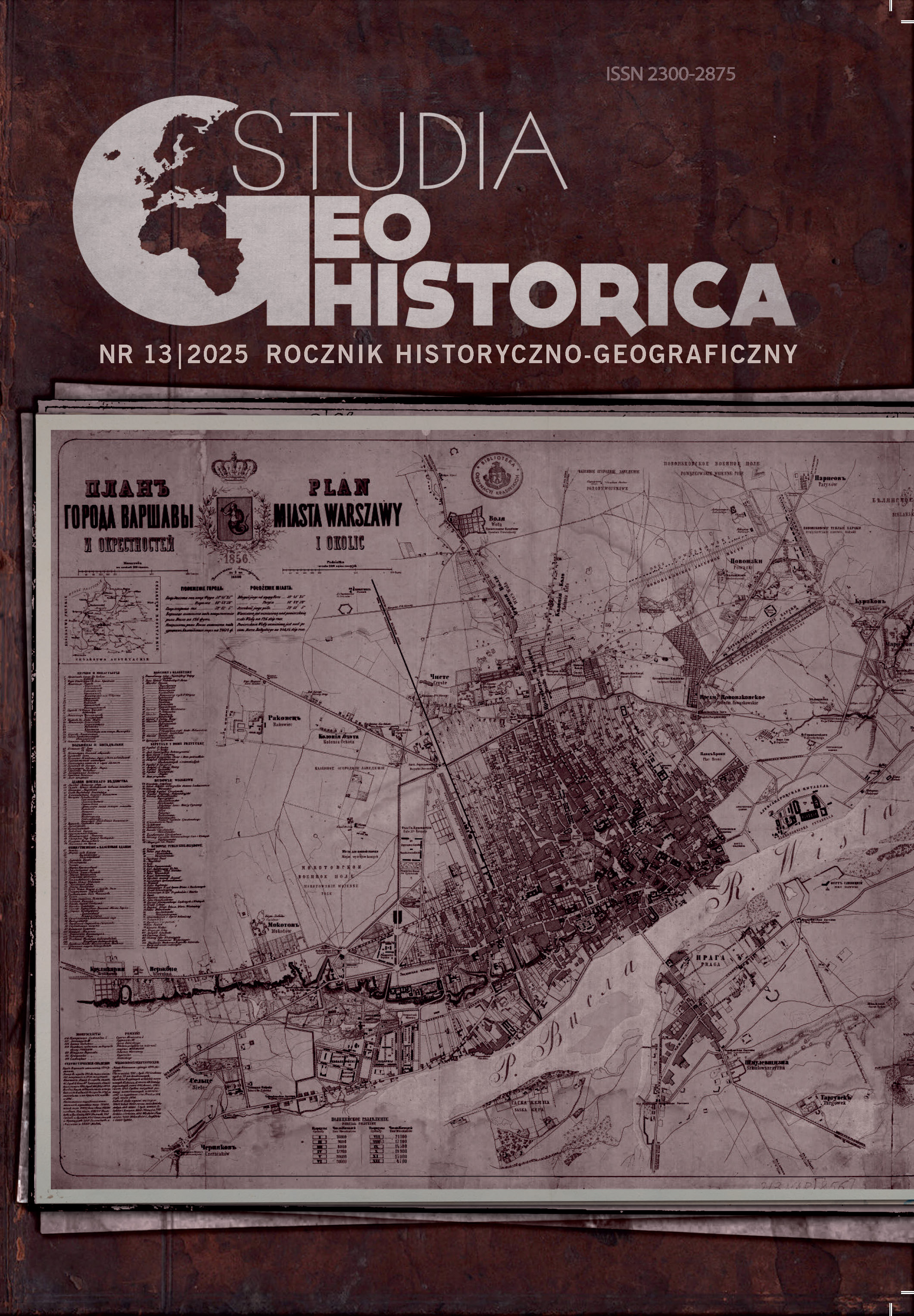
Digitally Reinterpreting the 1856 Map of Warsaw for Historical Engagement and Spatial Literacy
DOI:
https://doi.org/10.12775/SG.2025.07Palabras clave
historical cartography, historical map editing, digital humanities, critical cartography, historical education, WarsawResumen
The article presents a critical reinterpretation of the 1856 Plan of Warsaw and Its Surroundings. Rather than treating historic maps as static heritage, map editing is framed as an interpretive practice combining semantic analysis and visual redesign. The result is a structured version of the map aimed at fostering spatial literacy and public engagement. The article proposes a transferable workflow and reflects on the challenges of historical map editing in digital humanities.
Citas
Archival sources
National Library of Poland, shelf mark ZZK 1064, Plan goroda Varšavy i okrestnostej = Plan miasta Warszawy i okolic. Drawn under the supervision of K. Witkowski. Warsaw, 1856.
State Archives in Warsaw, shelf mark 785, Plan niwelacyjny miasta Warszawy. Drawn under the supervision of W. H. Lindley, 1897–1901.
Secondary literature
Baiocchi V., Lelo K., Milone M.V., Mormile M., ‘Accuracy of Different Georeferencing Strategies on Historical Maps of Rome’, Geographia Technica, 1 (2013), pp. 13–16.
Bartoszewicz H., Weszpiński P.E., Plan Warszawy 1825. Korpus Inżynierów Wojskowych (Warszawa, 2017).
Battersby S., ‘Web Mercator: Past, Present, and Future’, International Journal of Cartography, 11, no. 2 (2025), pp. 272–73.
Black A.L., Crimmins G., Listening to Children: Using Children’s Perspectives to Inform the Provision of Responsive Environmental Education at the Mary Cairncross Scenic Reserve and Discovery Centre (University of the Sunshine Coast, 2017).
Bodansky E., Pilouk M., ‘Using Local Deviations of Vectorization to Enhance the Performance of Raster-to-Vector Conversion Systems’, International Journal on Document Analysis and Recognition, 3 (2000), pp. 67–72.
Chełmiński J., Wasilewicz M., ‘Przez centrum Warszawy płynęły rzeki. Zobacz je na mapie’, Gazeta Wyborcza, https://warszawa.wyborcza.pl/warszawa/7,54420,26981804,przez-centrum-warszawy-plynely-rzeki-zobacz-je-na-mapie-a.html (accessed: 16 July 2025).
Deeb R., Ooms K., De Maeyer P., ‘Typography in the Eyes of Bertin: Gender and Expertise Variation’, Cartographic Journal, 49, no. 2 (2011), pp. 176–85.
Dumont H., Istance D., Benavides F. (eds), The Nature of Learning: Using Research to Inspire Practice (Paris, 2010).
Edney M.H. ‘Putting “Cartography” into the History of Cartography: Arthur H. Robinson, David Woodward and the Creation of a Discipline’, Cartographic Perspectives, 51 (2005), pp. 17–20.
Gawryszewski A., Ludność Warszawy w XX wieku (Warszawa, 2009).
Gregory I., Ell P., Toward Spatial Humanities: Historical GIS and Spatial History (Cambridge, 2007).
Harley J.B., ‘Deconstructing the Map’, Cartographica, 26, no. 2 (1989), pp. 11, 13–14.
Justová P., Cajthaml J., ‘Cartographic Design and Processing of Originally Printed Historical Maps for Their Presentation on the Web’, ISPRS International Journal of Geo-Information, 12, no. 230 (2023), pp. 14–15.
Koryś P., ‘On the Peripheries of the Modern Western World: Delayed Social Reforms and Unfinished Industrial Revolution (1830–1870)’, in: Poland from Partitions to EU Accession. A Modern Economic History, 1772–2004 (Cham, 2018), pp. 131–32.
Panecki T., ‘Digital Methods in Cartographic Source Editing’, Digital Scholarship in the Humanities, 36, no. 3 (2021), pp. 682–97.
Panecki T., ‘Plan of Kalisz by Andrzej Politalski from 1785 – A Source Edition in the Polish Historic Towns Atlas’, Polish Cartographical Review, 54, no. 2 (2022), pp. 93–94, 95–98, 104–06.
Rodger R., Rau S., ‘Thinking Spatially: New Horizons for Urban History’, Urban History, 47 (2020), pp. 373–74, 378–80.
Scanlon E., ‘Digital Scholarship: Identity, Interdisciplinarity, and Openness’, Frontiers in Digital Humanities, 5, no. 3 (2018), https://doi.org/10.3389/fdigh.2018.00003.
Schweyer A.-V., Mermet E., Paget A., Khounlivong E., Noûs, C., ‘Contribution of the Digital Humanities to Historical Research in Central Vietnam: GIS & Semantic Web Annotations’, HAL Archives Ouvertes, (2021), pp. 1–10.
Seegel S., ‘Four Purposes of Early 19th-Century Polish National Cartography’, in: id., Mapping Europe’s Borderlands: Russian Cartography in the Age of Empire (Chicago, 2012), pp. 89–109.
Słomska-Przech K., ‘Lindleys’ Map of Warsaw (1:2,500) as a Tool for Understanding the Urban Space Preservation’, Studia Geohistorica, 11 (2023), pp. 159–82.
Słomska-Przech K., Lilley K.D., ‘Cartography and the City: Exploring Urban Ontologies through Historic Town-Maps’, in: Modelling the City: Formal Ontology and Spatial Humanities, ed. W. Duży (London – New York, 2024), pp. 153–81.
Świątkowski H., Taryfa domów miasta Warszawy i Pragi z planem ogólnym i 128 szczegółowych planików ulic i domów (Warszawa, 1852).
Wiberley S.E., ‘Editing Maps: A Method for Historical Cartography’, Journal of Interdisciplinary History, 10, no. 3 (1980), pp. 499–502, 508–09.
Zejdlik J., Voženílek V., ‘Exploring Cartographic Differences in Web Map Applications: Evaluating Design, Scale, and Usability’, ISPRS International Journal of Geo-Information, 14 (2025), https://www.mdpi.com/2220-9964/14/1/9.
Zestawienie znaków topograficznych map: austrjackich, niemieckich i rosyjskich (Warszawa, 1925).
Internet sites
National Official Register of the Territorial Division of the Country. https://eteryt.stat.gov.pl/eTeryt/english.aspx (accessed: 16 July 2025).
OpenHistoricalMap, https://openhistoricalmap.org (accessed: 16 July 2025).
OpenStreetMap Carto Stylesheet, GitHub, https://github.com/gravitystorm/openstreetmap-carto (accessed: 16 July 2025).
SVG Repo. https://www.svgrepo.com/ (accessed: 16 July 2025).
Descargas
Publicado
Cómo citar
Número
Sección

Stats
Number of views and downloads: 228
Number of citations: 0
